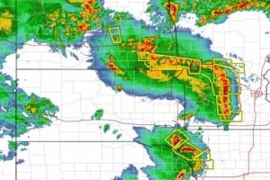
A rare particularly dangerous situation alert was sent out by the National Weather Service (NWS) for parts of Iowa, Minnesota, Nebraska, and South Dakota Thursday afternoon.
Widespread damaging winds including gusts up to 105 MPH are expected.
There have been over 200 reports of wind damage to the NWS already. See: Disaster Dashboard Incident Command
Here are some of the images from the storm so far. Most are out of Sioux Falls.
Join our email to hear about new resources to help you stay on top of severe weather outbreaks
- Disaster Relief Needs X (You should use it too)
- Faith in Action: Responding to Trump’s Reduction in Humanitarian Aid
- How to Help Someone Who is on Fire
- How To Get Help When 9-1-1 Is Down
- Does a Solar Eclipse Really Warrant a State of Emergency?
- The Coming Digital Apocalypse?
- Disaster Survival: Do These 3 Things Within 60 Seconds
- 5 Disaster Relief Tips for a Major Earthquake Response
- Can We Shoot the Chinese Balloon Down?
- Incident Management Team: Tips for a Successful Deployment
- TC001 Best New Thermal Camera? Review for TOPDON TCView
- 5 Ways To Stop Overpaying For Healthcare
Get the best laundry soap for your next adventure!
- Smaller & lighter than laundry pods
- Dissolves rapidly
- Less likely to be eaten by teenagers (hopefully)
- Does not melt
- 10 loads of detergent donated for every package purchased (See our review)


