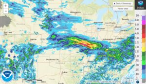
Extreme rainfall has led to flooding across the St. Louis region.
The metro area received 4-10 inches of rain leading to flash flooding across the area. The National Weather Service is expecting to see up to 12 inches of rain in some areas.
Several stream flow indicators are showing >90% of normal river levels, the highest possible reading for the sensors. See Flooding Dashboard
The previous rainfall record was set back in 1915 with 6.85 inches.
I-70 flooded
Multiple road closures due to flooding are being reported by MODOT on their travel map.
Join our email to hear about new resources to help you stay on top of severe weather outbreaks
- Disaster Relief Needs X (You should use it too)
- Faith in Action: Responding to Trump’s Reduction in Humanitarian Aid
- How to Help Someone Who is on Fire
- How To Get Help When 9-1-1 Is Down
- Does a Solar Eclipse Really Warrant a State of Emergency?
- The Coming Digital Apocalypse?
- Disaster Survival: Do These 3 Things Within 60 Seconds
- 5 Disaster Relief Tips for a Major Earthquake Response
- Can We Shoot the Chinese Balloon Down?
- Incident Management Team: Tips for a Successful Deployment
- TC001 Best New Thermal Camera? Review for TOPDON TCView
- 5 Ways To Stop Overpaying For Healthcare


