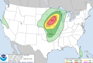
The National Weather Service has reported several tornados in Nebraska and Iowa so far tonight. Our live coverage has concluded.
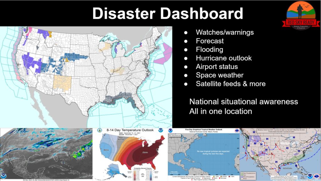
See our Disaster Dashboard
Embedded posts are preliminary, as is the information in this article. Verify information from multiple sources. Primary information from www.weather.gov
For warnings, please stay tuned to local news and have a NOAA Weather Radio or emergency alerts enabled on your phone.
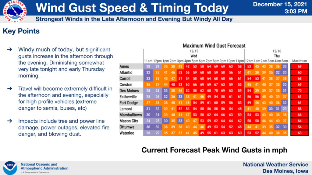
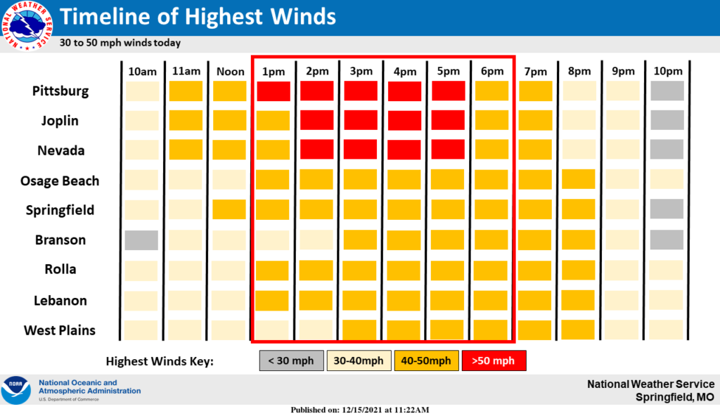
Multiple states were under high wind warnings, with wind gusts reported anywhere from 40 to 100 plus mph.
Power outages are being reported across many states. To see current outages, see poweroutage.us
See our power outage tips here.
Total outages reported by poweroutage.us at 9:15 PM 12-15-21
Iowa 145,000
Kansas 103,000
Missouri 62,000
Colorado 62,000
Iowa
The line of severe storms has crossed through Iowa.
Several tornado warnings have been issued in Iowa as of 4:34
* At 437 PM CST, a tornado producing storm was located over Minden,
  or 27 miles northeast of Omaha, moving northeast at 80 mph.
At 440 PM CST, a confirmed tornado was located near Kingsley, or 18
miles southeast of Le Mars, moving northeast at 70 mph.
At 446 PM CST, a confirmed tornado was located 8 miles northwest of
Griswold, or 12 miles west of Atlantic, moving northeast at 80 mph.
This tornado will be near...
  Marne around 455 PM CST.
  Atlantic around 455 PM CST.

Other locations impacted by this tornadic thunderstorm include Wiota,
Lake Anita State Park, Lewis, Cumberland, Griswold Park, Cold Springs
State Park, Atlantic Municipal Airport, Anita Municipal Airport,
Anita and Marne.
At 451 PM CST, a confirmed tornado was located 7 miles northeast of
Persia, or 25 miles south of Denison, moving northeast at 60 mph.
This tornado will be near...
  Harlan around 455 PM CST.
Storm spotter has reported a tornado on the ground near I-80 northeast of Atlantic at 5:04
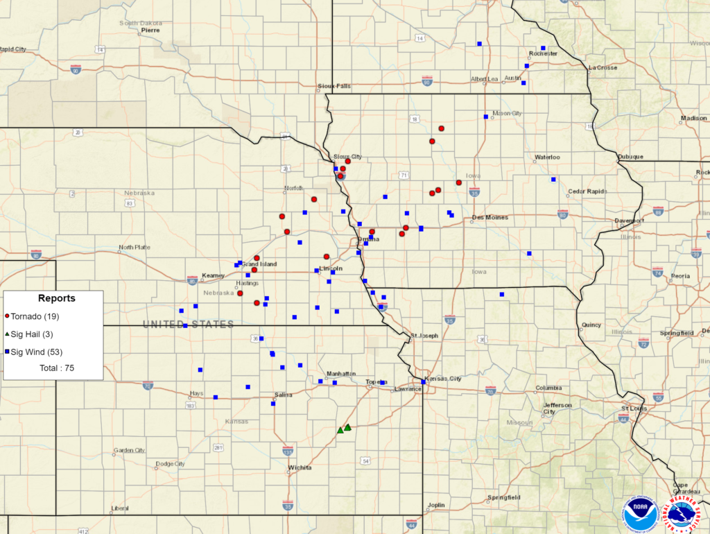
Additional tornados can be seen in the preliminary map above.
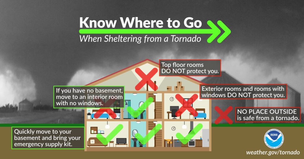
During a Tornado Warning
TAKE COVER NOW! Move to a basement or an interior room on the lowest
floor of a sturdy building. Avoid windows. If you are outdoors, in a
mobile home, or in a vehicle, move to the closest substantial shelter
and protect yourself from flying debris.
Missouri
Radar indicated rotation at 4:51 in NW mo
Nebraska
Confirmed tornado touchdown in Ayr and Beemer Nebraska.
Looking to the northwest from Lincoln in the direction of the potential tornado. pic.twitter.com/j5WX6hJ3U3
— Travis Klanecky (@Travis_Klanecky) December 15, 2021
Confirmed tornado near Ayr, NE. Moving NE 70 mph+. Take cover now Pauline, Glenvil, NE. Little to no time! Act now! #newx pic.twitter.com/hHEqUXuCdV
— Professor Ben Alonzo (@benbiotic) December 15, 2021
Multiple tornadoes are being produced by this line near Hastings NE. Expect this trend to continue as it heads NE through eastern NE and SW IA at 70-80mph! pic.twitter.com/X2EPavYRhH
— NWS Omaha (@NWSOmaha) December 15, 2021
80-90 mph wind gusts with nickel size hail being reported. The storm system are moving northeast at 60 to 95 mph. TV station 10/11 NOW reports this being some of the shortest duration tornado warnings they have ever seen because of the speed of the system.
Rotation and cloud lowering are being reported in Nebraska at 3:27. NW Lancaster county has activated its storm sirens. Dime size hail was reported near Emerald.
Roof reported off of home in Columbus by storm spotter.
Storm spotters have confirmed a tornado in Beemer with half-dollar-sized hail. Approx at 3:45
At 353 PM CST, a tornado producing storm was located over Yutan, or
  20 miles west of Omaha, moving northeast at 75 mph.
This tornadic storm will be near...
  Elkhorn around 400 PM CST.
  Arlington around 405 PM CST.
  Kennard around 410 PM CST.
At 405 PM CST, a confirmed tornado was located 6 miles southeast of
Emerson, or 22 miles southwest of Sioux City, moving northeast at 60
mph. A second confirmed tornado was located 5 miles southwest of
Winnebago, also moving northeast at 60 mph.
Heavy rainfall may hide this tornado. Do not wait to see or hear the
tornado. TAKE COVER NOW!
MAX HAIL SIZE...1.00 IN
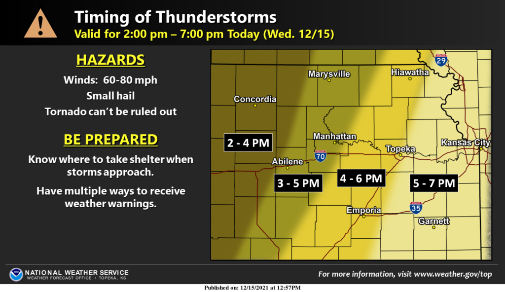
Kansas
Severe Thunderstorm Warning: Previous reports in Kansas included… HAZARD...70 mph wind gusts.
SOURCE...Radar indicated.
IMPACT...Expect considerable tree damage. Damage is likely to
mobile homes, roofs, and outbuildings.
unprecedented
Weather forecasters are describing this as yet another unprecedented weather event. Both the warm December temperature and the speed of the storms racing across the US will likely be something for the record books.
Stay up to date with the Disaster Dashboard
Be prepared for severe weather
Join our email to hear about new resources to help you stay on top of severe weather outbreaks

- Disaster Relief Needs X (You should use it too)

- Faith in Action: Responding to Trump’s Reduction in Humanitarian Aid

- How to Help Someone Who is on Fire

- How To Get Help When 9-1-1 Is Down

- Does a Solar Eclipse Really Warrant a State of Emergency?

- The Coming Digital Apocalypse?

- Disaster Survival: Do These 3 Things Within 60 Seconds

- 5 Disaster Relief Tips for a Major Earthquake Response

- Can We Shoot the Chinese Balloon Down?

- Incident Management Team: Tips for a Successful Deployment

- TC001 Best New Thermal Camera? Review for TOPDON TCView

- 5 Ways To Stop Overpaying For Healthcare